


The use of drone technology is already firmly established in many industries. As a result, the processing of recorded data has become an important part of work processes. A notebook provides a versatile basis for analyzing and editing drone videos.
Areas of application for drone video analysis
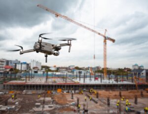
Drones are already being used successfully in numerous areas. In agriculture and forestry, they record areas and provide valuable information on land use, harvest planning or identifying damage to plants. In construction and infrastructure inspections, drone images help to document bridges, wind turbines or construction sites and support the inspection of structures. Rescue and emergency services also benefit from the recorded videos, as they enable rapid reconnaissance of emergency and disaster areas. Other scenarios in which drones are used include mountain rescue in the search for missing persons, environmental monitoring, for example when observing animal populations and detecting environmental pollution or analyzing climate data.
In these fields of application, it is important to analyze and process the video data in order to obtain meaningful results.

Notebook requirements for video analysis
Notebooks that are used for the analysis of drone videos should have powerful hardware to ensure the processing of high-resolution videos. Fast processors, sufficient RAM and hard disk space and a high-quality graphics card are decisive factors. As a lot of work takes place outdoors and in harsh environments, a long battery life is another important criterion. Robust housings offer protection against moisture, dust and impacts thanks to IP65 and military standard (MIL-STD-810H), while a bright display makes it easier to use even in bright daylight. Reliable connectivity is also required so that data can be transferred smoothly from the drone to the notebook. USB ports, card readers and wireless connections such as Bluetooth are an advantage here.
The typical workflow
A typical workflow when analyzing drone videos begins with the transfer of the recorded data. This is often imported to the notebook via SD cards, USB ports or wireless connections. The recordings are then analyzed using special software tools, such as GIS programs or video editing software.
A GIS program (geographic information system) enables the processing and analysis of spatial data. With the help of this software, drone images can be precisely integrated into maps, measured and combined with other geographical information. This makes it easier, for example, to identify changes to areas, create inspection reports or generate detailed site plans.
The relevant sequences can be examined more closely and prepared for further processing. In the next step, the important sequences are cut, marked and prepared for reports or presentations. Finally, all relevant information is saved on external storage media or in the cloud.
Advantages of combining notebook and drone
The combination of drone and notebook enables a mobile and flexible way of working. The direct processing of videos on site makes it possible to make decisions promptly. At the same time, the workload is reduced as repeat flights can often be avoided. This way of working supports a targeted and structured approach to analyzing and processing the recorded data.
Conclusion
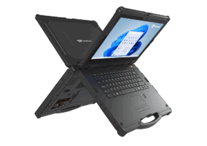
The processing and analysis of drone videos benefit considerably from the performance of modern notebooks. Our fully rugged, high-performance Rockbook X540 G3 and Rockbook X550 G3 notebooks are specially designed for data- and graphics-intensive tasks in the field. With Intel® Core™ Ultra processors of the Meteor Lake generation and dedicated Intel Arc graphics processors, they offer the necessary computing and graphics power to efficiently process high-resolution drone videos and perform complex analyses.
Thanks to powerful hardware and comprehensive connectivity options, video data can be transferred directly from the drone to the notebook and analyzed on site. The AI-supported functions thanks to Intel® AI Boost support the evaluation of image and video material, whether in agriculture and forestry, infrastructure monitoring or rescue operations.
The fully rugged design and the bright displays used make the notebooks suitable for demanding and harsh environments, while versatile expansion options and security functions make them a reliable solution for mobile use.
You can find an overview of our rugged notebooks in the Rockbook X500 G3 series here: https://www.werocktools.com/rugged-notebooks/
If you would like a free consultation on the subject of rugged laptops and the use of drones, we will be happy to help you find a suitable solution for your company. https://www.werocktools.com/contact
We look forward to hear from you.